
Media
HKU Scientists Map Urban Light Pollution
Engage Community in Tracking via Smartphones
27 Jul 2025
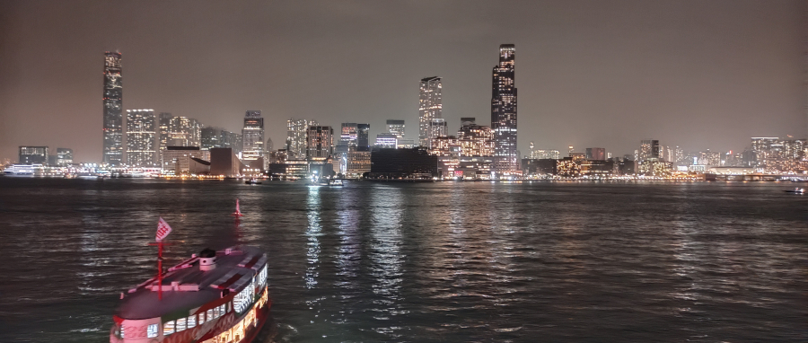
Images of coastal Tsim Sha Tsui taken on March 27, 2021 during the one-hour lights-out event. Image credit: Hong Kong Light Pollution Research Project Team, HKU
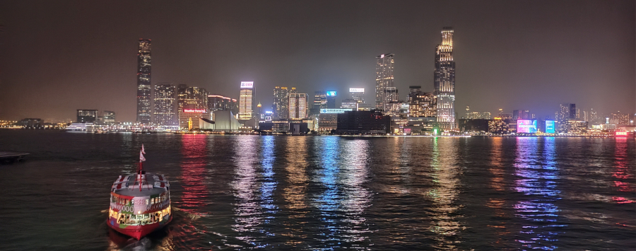
Images of coastal Tsim Sha Tsui taken on March 27, 2021 after the one-hour lights-out event. Image credit: Hong Kong Light Pollution Research Project Team, HKU
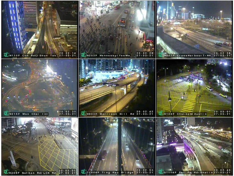
Images captured by CCTV installed by the Transport Department taken on March 27, 2021 before the one-hour lights-out event.
Image credit: Transport Department.
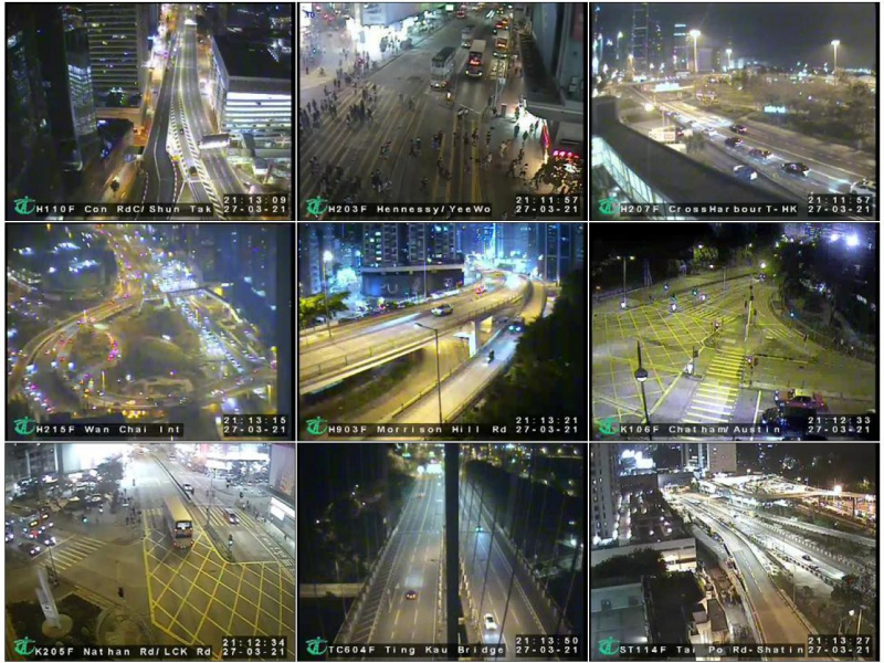
Images captured by CCTV installed by the Transport Department taken on March 27, 2021during the one-hour lights-out event.
Image credit: Transport Department.
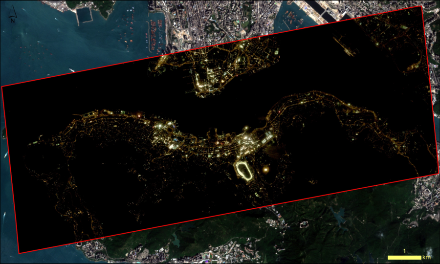
Ultra-high-resolution (inside the red frame, spatial resolution around 1m) images captured by the Jilin-1 satellite system. Image credit: Hong Kong Light Pollution Research Project Team, HKU.
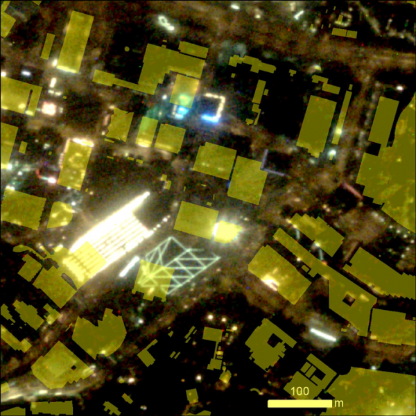
High resolution (spatial resolution around 1m) image of Central captured by Jilin-1 satellite overlaid with the footprint (yellow polygons) of individual buildings and structures recorded in the CDSI Portal. Image credit: Hong Kong Light Pollution Research Project Team, HKU.
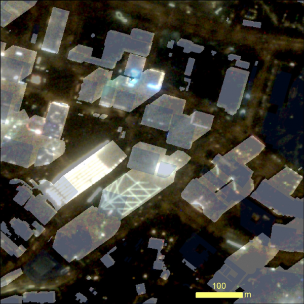
Light emitted by each building in the analysis had been conducted with the height of buildings from the CDSI Portal included (white polygons). Image credit: Hong Kong Light Pollution Research Project Team, HKU.
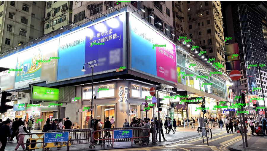
Output of the AI light source detection program. Utilizing deep learning, the AI algorithms distinguish objects from the background, enabling the identification of objects that emit light sources (labeled in green). The development of the External Lighting Index reflects the state of light pollution based on a large number of photos collected from various locations in Hong Kong. Image credit: Hong Kong Light Pollution Research Project Team, HKU.
Light pollution, defined as the improper use and overexposure to artificial light at night, has emerged as a significant global environmental issue with far-reaching consequences. Research shows that artificial light disrupts natural day-night cycles, impacting the physiology, behavior, and evolution of both flora and fauna. In humans, prolonged exposure to nighttime light has been linked to various health issues stemming from circadian rhythm disruption. Additionally, light pollution impairs astronomical observations and contributes to energy waste. These diverse effects highlight the urgent need to better understand and address the impact of light pollution.
Against this backdrop, a research team from the Department of Physics at The University of Hong Kong (HKU) has uncovered striking pattern in Hong Kong’s urban lighting using innovative multi-source monitoring strategies. Their findings reveal that the distribution of light pollution in the city is highly uneven, with a disproportionate share originating from a small number of decorative lighting installations concentrated in just a few districts. Specifically, decorative lighting from approximately 120 buildings accounted for half of the night sky brightness measured above the Victoria Harbour, while just five districts were responsible for more than half of the total light emitted from both sides of the Harbour. Their findings provide science-based solutions to this pressing environmental challenge.
Lights-out natural experiments reveal major impact of few decorative lights
The team monitored over a decade of the annual lights-out events held each March between 2011 to 2024, using data from HKU night sky monitoring network stations. They found that sky brightness on either side of the Victoria Harbour dropped by up to 50% during the one-hour switch-off. By examining multi-source monitoring imagery collected citywide—including tram recordings, public footage, and survey camera images—the researchers identified around 120 individual lighting fixtures, mostly mounted on buildings, that participated in the 2021 lights-out events. Further analyses revealed that billboards and floodlights are among the most significant contributors to urban light pollution.
“By comparing videos taken onboard the tram during lights-out events and on regular evenings, our observations provide compelling evidence that turning off a small but critical number of decorative lights in commercial districts can significantly impact urban light pollution levels,” explained Dr Jason Chun Shing PUN, the lead researcher. These findings have been published in the journal Scientific Reports.
Ultra-high-resolution satellite imaging uncovers unexpected sources
To map the distribution of lighting sources in Hong Kong, the team examined an ultra-high-resolution nighttime satellite image, which revealed a starkly uneven distribution of light across both sides of Victoria Harbour. Remarkably, more than half of the external light emanates from just five districts: Central, Happy Valley, Tsim Sha Tsui West, East Tsim Sha Tsui & King’s Park, and Causeway Bay (see note). The image also allows a detailed breakdown of light sources by category: buildings accounted for 42%, parks and sports facilities 17%, and streets, highways, and others 41%.
Dr Jason Pun noted, “The substantial contribution from residential buildings suggests that we need to rethink how we address light trespass and nuisance in residential environments.” This research findings were published in the journal IEEE International Geoscience and Remote Sensing Symposium in 2023.
Towards Smarter Lighting: harnessing AI innovation and public engagement
To better understand how light pollution affects people, the research team developed sophisticated artificial intelligence (AI) algorithms capable of automatically detecting and classifying light pollution sources from smartphone photos. Leveraging state-of-the-art advancements in object detection and segmentation through deep learning, the algorithms support the creation of a novel External Lighting Index to help assess the level of light nuisance across different urban settings.
The project also incorporates a citizen science component, encouraging the public participation in monitoring light pollution through a dedicated web platform. Citizens can contribute research data simply by uploading nighttime photos taken with their smartphones. “By combining cutting-edge technology with public participation, we're fostering a more comprehensive understanding of light pollution patterns,” said Dr Pun. The platform is accessible at: https://app.nightsky.physics.hku.hk/static/index.html
The collective findings lead to several important recommendations for lighting policies. The research suggests that regulating non-essential commercial lighting, optimizing building illumination, and developing comprehensive light pollution metrics could significantly reduce urban light pollution without compromising the functionality of the city.
The research was funded by the Environment and Conservation Fund of The Government of the Hong Kong Special Administrative Region (Project ID: 125/2018, 113/2022) and the Faculty RAE Improvement Fund of HKU. The two ECF grants funded the establishment of night sky measurement stations to study changes in night sky brightness during Earth Hour. Additionally, grant 113/2022 supported the acquisition of high-resolution satellite imagery. The RAE Improvement Fund also contributed to the setup of night sky measurement stations and the analysis of various monitoring images, helping to determine which lights were actually turned off during Earth Hour across different years.
Any opinions, findings, conclusions or recommendations expressed in this press release do not necessarily reflect the views of the Government of the Hong Kong Special Administrative Region and the Environment and Conservation Fund.
For more details, please refer to the publications:
‘Natural experiments from Earth Hour reveal urban night sky being drastically lit up by few decorative buildings,’ published in Scientific Reports: https://www.nature.com/articles/s41598-025-05279-4.
‘Using High-Resolution Nighttime Remote Sensing Data to Identify Light Sources in Hong Kong,’ published in IGARSS 2023 - 2023 IEEE International Geoscience and Remote Sensing Symposium: https://ieeexplore.ieee.org/abstract/document/10283198.
Note 1 The five small districts represent five District Council Constituency Areas (DCCAs) based on Constituency Boundary Maps from the 2019 District Council elections.
For media enquiries, please contact HKU Faculty of Science (tel: 852-3917 4948/ 3917 5286 ; email: caseyto@hku.hk / cindycst@hku.hk ).
Images download and captions: https://www.scifac.hku.hk/press
Earth Hour 2021 tram video: Night scenes from Sai Ying Pun to Causeway Bay captured by a camera mounted on a tram taken one day before and during the one-hour lights-out event.
Full videos of the tram ride can be found at https://youtu.be/mvuLtZKJbrg
Video credit: Hong Kong Light Pollution Research Project Team, HKU.
Supplementary Information on Light Pollution
HKU Night Sky Monitoring Network Stations
Launched in 2010, HKU has been monitoring night sky brightness using the Sky Quality Meter (SQM), a compact, playing-card-size device imported from Canada that provides instant and accurate reading. As of July 2025, a network of 12 monitoring stations operates across Hong Kong, capturing sky brightness data every 30 seconds under diverse urban and rural conditions. Stations in Hong Kong are part of the Globe at Night - Sky Brightness Monitoring Network, which builds on the infrastructure developed by HKU in 2014. The network includes 90 monitoring stations across all continents except Antarctica.
Lights-out Natural Experiment
The annual one-hour lights-out event that takes place between 8:30pm – 9:30pm on a Saturday in March serves as a natural experiment to investigate the environmental impact of urban lighting. It is a part of Earth Hour, a global initiative by the World Wide Fund for Nature (WWF) that promotes collective environmental action by encouraging individuals and business to turn off non-essential lightings for one hour.
Multi-source Monitoring Strategy to Monitor Lighting Conditions
The HKU team adopted a multifaceted campaign to monitor lighting conditions in Hong Kong during the period. In 2021, they videotaped tram rides from Sai Ying Pun to Causeway Bay one day before (March 26, 2021), and the day of Earth Hour (March 27, 2021). Omnidirectional cameras (360 cameras) were deployed on both sides of the Victoria Harbour to continuously monitor lighting fixtures facing the Harbour. The team also inspected the all-sky images taken at Tsim Sha Tsui to identify changes in lighting conditions of nearby buildings. Furthermore, images from 120 Closed Circuit Television (CCTV) cameras installed by the Transport Department(1), which fully or partially captured nearby building conditions, and images captured by weather cameras uploaded by the Hong Kong Observatory(2) were analyzed to detect changes in lighting conditions during Earth Hour. Finally, Research Assistants were deployed to record conditions of lighting before, during and after Earth Hour 2021 in Mongkok, Tsim Sha Tsui, Central, Wan Chai, Causeway Bay, Tsuen Wan, Kowloon Bay and Wong Tai Sin, etc.
1 Real-time Road Traffic Information: https://www.hkemobility.gov.hk/en/traffic-information/live/cctv/
2 Hong Kong Observatory Latest Weather Photo: https://www.hko.gov.hk/en/wxinfo/ts/index_webcam.htm
Ultra-High-Resolution Nighttime Satellite Image Analysis
Ultra-high-resolution nighttime satellite images of Hong Kong were captured by the Jilin-1 satellite system, operated by the Chang Guang Satellite Technology Co, Ltd. The HKU team put together a nighttime map of the city by combining approximately 20 separate images taken between August and November 2021. These images offer an overall spatial resolution of around one meter. To analyze the origin of light detected in the high resolution image, we integrated the satellite image into the Geographic Information System (GIS) and analyzed it along with the Common Spatial Data Infrastructure (CSDI) Portal developed by the Lands Department of the HKSAR Government(3). To capture the actual light emission by buildings in these off-nadir (that is, not taken vertically above) images, the HKU team included both the footprint and the height of each individual building recorded in the CSDI Portal.
3 Common Spatial Data Infrastructure Portal: https://portal.csdi.gov.hk/csdi-webpage/